

| Start Date | 2020-08-14 |
| End Date | 2020-09-07 |
| Days | 24 days |
| Distance | 600km |
A return to trekking after the last couple of trips by bike. 400 miles across volcanic desert should be gruelling enough to shed some lockdown pounds...
Logistics
Getting to the start at Hraunhafnartangi lighthouse (near village of Raufarhöfn)
Due to our limited time window, we took the quickest option - We flew with Eagle Air from Reykjavik city airport to Husavik, a 50 minute flight with the bonus of some great views of the landscape
Cost £107 each
https://www.eagleair.is/
Alternatively you can get a bus from Reykjavik to Akureryri (which takes all day), and there USED to be a bus onwards to Raurhofen, but no longer. Hitching is famously viable in Iceland, but from Akureryri or Husavik it's still a 2-3 hour drive so you would be lucky, especially in the far north where there isn't all that much to see Having said that, at the lighthouse we did find 2/3 vehicles, of tourists going to check out the most northerly point. Close to Raufarhöfn, the Arctic Henge project is probably helping to lure curious travellers to the area.
Anyway, to meet our schedule, from Husavik the only option was to take a taxi:
https://travelnorth.is/
Gunnar from Travel North met us at the airport, and was a great help with a wealth of local knowledge and information on the scenery and geology along the way
COVID testing
First test at the airport in a highly organised manner. Received the all-clear text message by about 11pm that evening.
When we arrived in Iceland, regulations allowed travel during the first 5 days before taking a second test, with precautions being taken to avoid crowded places, wear a mask etc, so we figured starting our walk would be a reasonable way of staying isolated during this time.
With this in mind, we could get as far as Lake Myvatn before taking the second COVID test
The nearest test centre was in Akureyri, open 10am - 3pm Mon-Fri. The one bus from Myvatn would arrive in Akureryi at 3:30pm, so instead we hired a car, thanks to Karl at six60, now located just behind the supermarket in Myvatn https://six60.is/
This cost ~ £70 for the day, but was very convenient, allowed us to do a supermarket trip, and stop off at the charming Godafoss waterfall.
Again received the all-clear result the same evening.
All the shops we went into seemed well stocked for hiking and camping, with racks full of protein bars, beef and fish jerky, dehyrdated camping meals (including instant mash, pasta, cous cous, noodles) Many shops as well as campsites sold gas canisters (though be careful of the different types...), less places sold methlyated spirits for my Trangia stove (known as Rotsprit, red in colour, sold in 1 litre bottles. i got some at a petrol station. Also available at camping store in Reykavik)
For our food parcels, we asked for cardboard boxes at the supermarkets. Andy brought some sellotape.
We did bring some food with us from the UK. Food is generally x2 the cost in supermarkets in Iceland
I brought a load of instant mash, beef jerky, malt loaf (i didn't see malt loaf in Iceland), mars bars
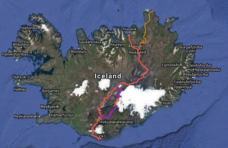
Section 1: Hraunhafnartangi to Asbyrgi (2.5 days)
Water top up less frequent than expected
N1 gas station at Asbyrgi - decent mini market (open till 9pm) / cafe (open till 7pm?)
Section 2: Asbyrgi to Lake Myvatn (2.5 days)
Water tanks at Dettifoss campsite (hikers only) toilets in dettifoss car park
water (stream) by Hilderhagi hut (south side of lake Eilifsvatn)
Comprehensive supermarket in Myvatn, we shopped in Akureyri since we had to go there anyway
Section 3: Myvatn to Dreki (Askja)(3 days)
Water available each day, but not regular intervals so carry a couple of litres
Section 4: Dreki to Landmannalaugar (8 days)
Dreki - here we collected a food parcel for our next 8 days, shipped from Myvatn with Mývatn Tours (thanks to Ragga and Gulli)
https://myvatntours.is
Cost 3000 ISK
We dropped a box off at their HQ in {} 3km south of Myvatn and it was delivered to the Wardens hut at Dreki site the next day
No reliable water for 2 days between Dreki and Gaesavatn. (Water may be available earlier at Kistufell, in the hut or from spring under Easter Island head) After that, regular river/stream crossings, some clear, some silty. Previous people doing this kind of traverse have also sent food to Nidalyur hut, but no tour bus was operating to go there this year, so we had to carry enough to get through to Landmannalauger This wasn't terrible though, as it meant we could cut the corner through the Vonarskard pass between Tungnafellsjokull glacier and Vatnajokull glacier, saving a day, and a pretty route.
Section 5: Landmannalaugar to Dyrhólaey (4 days)
At Landmannalaugar we collected food parcel for the remainder of the trip, which we had sent with Reykjavik Excursions (3000 ISK, we put on the highland bus at 7:30am at the BSI bus terminal in Reykjavik)
https://www.re.is/contact
Again this was delivered to the campsite wardens. Landmannalaugar also has the "Highland Mall" shop located in 3 old school buses, but this was closed when we arrived (2nd september) The campsite here and at the huts along the Laugavegur trail sell chocolate bars, some cookable meals, basically enough to get by on, although more expensive than supermarkets. At Thorsmork we stayed at the ITA/FI campground (Langidular), where there is also a "shop" hut, also closed when we arrived. There is a posher hut round the corner at Husadalur with a restaurant and spa, but we didnt go past it. Plenty of clean streams for water / snow. At Skogafoss the campsite was deserted and the youth hostel was closed up with building works going on. As it was super windy and we were knackered, we dragged ourselves down the road in hopes of finding some accomodation, and lady luck landed us at the Hotel Skogar, with one room left at the inn. The staff could not have been more helpful, and we enjoyed hearty meals, a shower, hot tub and a nice bed. Decadent but we felt we deserved it. There is also a tourist info centre/cafe/shop at Skogar, but this was also closed. There were no facilities on the road between Skogar and Vik
Getting back from the end
As we approached Dyrhólaey headland /lighthouse there were plenty of cars on the road so we were optimistic about being able to hitch a ride into Vik. So it transpired, as we accosted a friendly looking young couple and bagged a lift into town (Thanks Baldwin & Henrika!) Here we celebrated with some great and not too expensive beers and burgers at the town microbrewery (Smidjan Brugghus) and a comfortable night at the Puffin Hostel (£60 for a twin room) Next day we caught the 51 bus back to Reykjavik (£29 each, 3 hours)
https://straeto.is/en/timatoflur/2/28
The bus leaves from outside the N1 petrol station, handily located next to a supermarket / cafe / massive "icewear" souvenir shop
In Reykjavik we celebrated further with a delicious meal at ROK restaurant, highly recommend that.
Other Notes
https://safetravel.is/travel-plan
I logged our itinerary via the website, and exchanged a few emails to check we were comfortable with our 35km per day plan, and with weather updates.
I checked in with our progress and route alterations.
We didn't carry a satellite PLB or use the daily monitoring service.
We walked between August 16th - September 4th.
Due to the stricter COVID19 regulations brought in after our arrival, essentially no additional tourists were arriving in the country after us, and coupled with the summer season effectively finishing at the end of august, many places were really quiet (which was nice for us)
We had great weather most of the way. Worst days were drizzly and windy, but never too depressing.
The first week was very sunny, i got badly sunburnt on my hands, as walking south they were always exposed, and i had not brought suncream
Between Lake Myvatn and the day AFTER Dreki, we were constantly bothered by flies clouding around our heads. Not biting, but often trying to fly into your eyes, up the nose, in the ears.
I resorted to wearing a headnet while Andy covered up best he could with buffs and sunglasses. Allegedly the flies are only usually a problem closer to the lake, but watch out.
On the F-road sections, generally saw 3-4 4x4s each day. Generally people waved and gave a questioning "everything ok?" thumbs up
Maps
I did all the navigation using my phone, with occasional compass bearings. Since the landscape is on such a large scale, and with few paths to get confused by, navigation is often as simple as "head for that distant mountain" or "go due south"
We did however carry on overview map of the country, and the detailed Iskort paper map of the section south of Vonarskard.
So, what digital maps are available....
http://vefsja.iskort.is/
This gives you the topographical maps with hiking routes etc, the same as the paper maps sold in book shops / campsites.
I wanted an offline copy of this, which was a bit awkward to get.
I use MOBAC to create offline atlases for use with OruxMaps app (free on android)
However, direct requests for tiles from the iskort do not work, so I has to manually scroll around the map and use Fiddler to save the tiles to use as an offline map source in MOBAC I am happy to provide a copy of the OruxMaps atlas if anyone wants it.
I also downloaded satellite imagery for offline use, which was REALLY helpful in identifying likely spots for wild camping, and which streams might actually exist / how big they might be vs the thin white line on the map.
On the ground, some trails on the map don't obviously exist, whilst unmapped well trodden sheep tracks or 4x4 tracks will often mysteriously appear and take you in the right direction for a while, before suddenly veering off somewhere else. More popular tracks generally marked with poles
https://www.map.is/
Has topo and satellite maps, but not perfect for hiking
OSMAND (open street maps for android, free) does show most features, but i prefer the aesthetic of the Iskort maps.
Route Notes
download gps gpx track of full route
Lots of 30km days due to timeframe vs distance between places / landscape. Would be possible to do more, shorter days, but means carrying more food. Start -> Asbyrgi is uninspiring, but gets the legs going.
Day from Asbyrgi to Dettifoss VERY nice, then to Myvatn via Krafla also interesting.
Myvatn -> Askja, 2 days repetitive, lava fields, tundra. Askja crater is pretty amazing.
Askja -> Gaesavatn = sandy desert with looming glacier, a different kind of monotony!
Gaesavatn -> Landmannalaugar.
Having read several blogs (some with the aid of google translate), i was hoping to avoid taking the F26 between Nyidalur and Landmannalaugar, and instead forge a scenic route first through Vonarskard, and then hugging close to Vatnajokull, skirting the Tungnaa river by sneaking onto the glacier for 10km to reach Langisjor The Iskort map shows 4x4 tracks and hiking trails connecting this up... however Iceland has a very seasonal and changeable landscape... Started off ok, a few easy river crossings, nice scenery, and great sense of being off the beaten track. But the plan was soon scuppered by the river Svedja? that flows out into Hagongulon lake. This river was far too big and ferocious, even having camped out by it until morning. We searched in the headwaters to see if it broke up into more manageable tributaries, but the main strand flows out of a steep sided canyon. Looking at the possiblity of skirting around on the glacier also proved offputting, as the seasonal retreat of the ice left behind a fringe region of silty muddy quicksand which felt like it would be easy to become dangerously stuck in. So we decided discretion was the better part of valour and backtracked to Svarthofol to take the easy track out to the west of Hagongulon lake. Yay 3 days on the gravelly, featureless F26! We should have asked for more local advice about this part. Unfortunately the rangers at Dreki were too hungover to help. Landmannalaugar -> Dyrhólaey. Via the deservededly popular Laugavegur / Fimmvorduhals trails, 3 days total. Tough due to sudden shock of climbing up and down steep hills Finally 27km of road to the lighthouse.
Equipment
I bought a new tent (Hilleberg Soulo) in anticipation of tough weather, which never really materialised. It was nice having a freestanding tent for some of the hard ground/sandy ground pitches, but Andy had a tunnel tent (Nordisk Svalbard) and never failed to get a good pitch with the help of a few big stones to help secure pegs/guy ropes.
Hiking Poles were indispensible as ever when carrying a heavy bag, uneven ground, river crossings, windy days, saving knees etc.
River Crossings - i took a pair of lightweight trail running shoes. Admittedly these were dead weight for 80% of the walk, but on the days where we crossed 5-6 rivers they were a godsend. Andy had neoprene socks with extra grippy bottoms, but against the stoney bottomed, wide braided rivers, these were not perfect. He did survive though, and i'd say having any defence (rather than bare footing it) against the cold cold water and stones is definitely beneficial
Power. I took a solar panel which was very effective in direct sunlight, but i could only really use it when we were stopped, since travelling south, and i couldn't mount it on my front. Also took 2 powerbanks (10,000 & 20,000), which all combined provided enough power to keep everything charged. Asked about recharging at Dreki and Landmannalaugar but reply was negative, so had to be more frugal with batteries towards the end. Phone always in airplane mode and would only turn on the GPS to check position. Recorded GPS tracks on Suunto Ambit Peak 3 watch (battery lasts about 10 days recording at 1 minute intervals) A front mountable solar panel would be worth researching. The second half of the trip we barely saw the sun though, in which case only helpful for devices that can manage with a low current (gps watch, mp3 player)
Useful blogs and resources
https://www.alicebowers.com/north-to-south-iceland
http://lukaszsupergan.com/crossing-iceland-traverse-the-route-and-preparations/
https://andrewskurka.com/adventures/iceland-traverse/
http://viajarapie.info/en/trips/iceland-north-to-south/
Regarding the glacier route...
https://www.youtube.com/watch?v=J8uFpJxWS5c&t=3s
https://www.youtube.com/watch?v=_fIwiThG_qM&t=330s
https://www.wikiloc.com/hiking-trails/iceland-trek-day-10-2016-08-22-from-north-to-south-33338080
http://barleybreeder.wordpress.com/
http://translate.google.de/translate?hl=de&sl=de&tl=en&u=http%3A%2F%2Fbarleybreeder.wordpress.com%2F
https://safetravel.is/crevasse-maps
http://www.alpine-rescue.org/ikar-cisa/documents/2019/ikar20190101006181.pdf